Reducing 1.2 Million Annual Slick Pavement Accidents
Slick driving surfaces (icy, snowy, and wet roads) cause more than 1.2 million crashes annually in the US, costing $31 billion. Flurry is a hardware-software combination that:
- maps persistent obstacles, such as black ice patches, using anonymized data
- alerts users of slick driving conditions
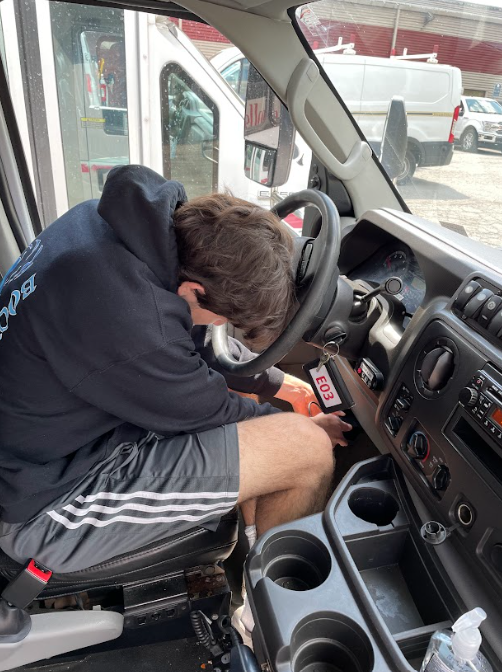
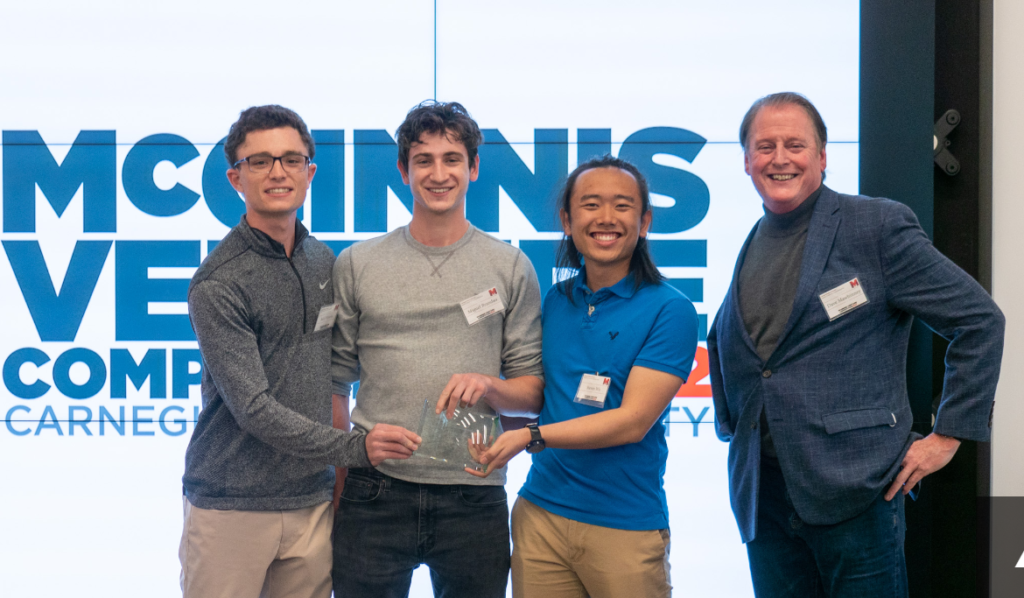
Flurry’s hardware component plugs into a car’s onboard diagnostic port and uses its built-in sensors to calculate the road’s slickness. The plug then connects with a mobile app or dispatcher network to recommend driving speeds and stopping distances and send road condition information to the cloud. In the future, we will monitor a car’s condition through metrics such as motor performance, battery health, and tire pressure to inform owners of other vehicle risks. Recently, our team won first prize in CMU’s annual McGinnis venture competition. For more detailed information, see below.
Problem: Driving on Slick Pavement
Born and raised in Minnesota, co-founder Miguel Brandao dealt with costly and dangerous icy conditions every October to March. He is not alone, as 70% of Americans live in hazardous winter conditions, and 50% don’t feel comfortable driving in icy conditions. Customer discovery led to countless horror stories of drivers sliding on ice, confirming research. Ice is just one part of a much larger problem: slick pavement. Federal Highway Administration data shows icy conditions are only 13% of weather-related accidents while hydroplaning and snowy surfaces cause 70% and 16% of weather-related accidents, respectively. These accidents cost individuals, businesses, and the government billions of dollars. Unfortunately, current solutions are not adequate for mitigating this problem:
- traction control often warns after a car has lost control
- special tires (such as studded tires) for poor road conditions are expensive and difficult to maintain
Experts reference driver’s speed and braking distance as critical components to avoid sliding on ice and hydroplaning. Drivers need a solution to alert them before slick surfaces arise.
Solution
Our solution is based on academic research into friction estimation using onboard car sensors. We plan to apply this research in a commercial context to help people drive safer. Information about the road and its risks will be integrated into existing mobile apps and car systems such as Google Maps and CarPlay. With this information, drivers will reduce their risk of an accident in bad weather.
Using a Car’s CAN-BUS System
The built-in CAN-BUS system helps all of the different parts of a car communicate with each other. It is similar to a brain in that it processes information from sensors and can send signals to other parts of the car. The onboard diagnostics system (or OBD), is a method of reading these signals and converting them into information that is useful to us, such as wheel speed and car temperature. This sensor data, along with a proprietary control algorithm and an accelerometer embedded in the OBD plug, will calculate road slickness in real-time. This method of processing car sensor data in real-time can also improve many other aspects of driving such as window defogging, pothole detection, and much more. We plan to explore these options once we have perfected our slickness detection algorithm.
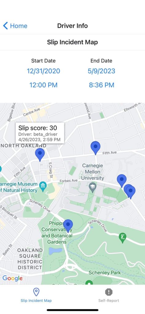
The Data Collection and Alert Process
This data is collected and processed throughout the entirety of a user’s drive. The data collected from every car is shared with every other car via a heatmap that shows the intensity of road slickness and the risk of a crash on any given road. Our algorithm will take this data, disassociate any personally identifiable information, and output recommendations to a user that makes them drive safer. It will recommend driving speeds, stopping distances, and alternate routes for a car given the road it is driving on. Our solution is an entirely hands-free, automatic, and drastically more accurate version of Waze. In Waze, users mark hazards to show up on the map for others––our solution is similar. However, instead of users marking distinct obstacles, their cars will automatically track the conditions of the roads they drive over. For example, if a driver encounters a patch of black ice and their sensors detect slipping, that data will be stored and all other drivers traveling on that road will be notified to adjust their speed or take an alternate route.
Direct and Indirect Competitors
An overview of alternate solutions and their drawbacks are shown below:
Table 1- Competition Overview
Preventative Solutions | Mitigative Solutions |
Weather Telematics Inc. Description: A telematics company that provides weather data and maps to truckers.
Waze Description: A navigation app that allows for crowdsourced hazard reporting.
| Studded tires Description: Custom tires with metal studs that help prevent sliding on ice
Tire chains Description: Aftermarket product that drivers can install on their wheels to prevent slipping.
|
As shown in table 1, preventative solutions are often inaccurate and expensive. Mitigative solutions are inconvenient, expensive, and often dangerous. Our product will fill the gaps that these solutions have. A subscription to our crowdsourcing and the alert system would be priced at $24/year, whereas studded and all-weather tires cost at least $220/year and Weather Telematics Inc. only custom prices. While Waze is free, it does not map weather hazards like black ice patches and hydroplaning zones accurately. Our solution is also more locationally accurate and will not damage your car.
Flurry as an Investment Opportunity
Flurry’s $30B Market
Flurry has B2B, B2B2C, and B2C plays that represent a market size greater than $15.1 billion per year. This number could grow significantly with autonomous vehicle (“AV”) and car manufacturing company partnerships.
B2B2C Early Adopters: Trucking Fleets and Insurance Companies
Trucking fleets (specifically in the Midwest) have emerged as our initial target market, as they deal with hazardous weather year-round. While owner-operators can choose not to drive in poor conditions, many fleet drivers must drive to get paid and have horror stories of jackknifing and sliding into ditches. 18-wheeler accidents are costly due to their cargo, high repair costs, and the damage they inflict on smaller vehicles and their passengers. We plan to reach out to mid-size trucking fleet dispatchers to gain our initial adopters. Parallel to this strategy, we will also advertise to popular trucking social media platforms, such as Trucker Report, Facebook Groups, and Reddit, to spur talk among truckers. As mentioned above, trucking fleets’ extensive driving can contribute immense value to Flurry by providing data that can kickstart Flurry’s crowdsourcing component. Assuming truckers drive an estimated 700 miles per day within a 46,876 miles long interstate system and that a new data point every hour is enough to provide up-to-date information about a given location on the road, we estimate that as little as 1,000 daily truck users or roughly 20 fleets can provide sufficient data to make our crowdsourcing component effective for the entire US interstate system. Achieving these same statistics with consumers will require tenfold more sales conversions. Following our trucking fleet sales campaign, we will then nurture our warm leads with insurance companies, which have also emerged as a top customer segment. We have had two separate State Farm Ventures meetings, including one with a scouting manager. Insurance agencies value technology that can keep policyholders safe to minimize claims and provide a competitive advantage. Ultimately, these two customer segments can benefit from Flurry and have extensive user bases that can build out Flurry’s database.
Financials: Subscription-based Revenue Growth
Flurry will sell the hardware component at its $15 cost to produce and will then have a $2/month/user app subscription fee that enables users to access heat maps and receive alerts. The customer discovery phase revealed that a majority of Flurry’s value lies in heat maps or data aggregation. Therefore, we want to maximize adoption rates instead of focusing on high device profit margins. We also intend to offer incentives, such as lower subscription fees, to initial adopters. Flurry will achieve a positive cash flow during Y3Q1 as its gross margins grow over time through our software subscription. Our initial target market is Minnesota truckers and insured drivers. Minnesota has roughly 34 thousand registered truckers and 3.3 million insured drivers. We intend to capture 1 percent of the Minnesota trucking market in Y2Q1 before adding 3 percent in Y2Q2, and 10 percent in Y2Q3. That number will then grow by 25% each quarter as Flurry adds more truckers from Minnesota and surrounding states. Beginning in Y2Q4, we start accounting for retaining 80 percent of users each quarter as some users may drop a subscription depending on the season. Then, we begin by adding insured drivers through insurance companies in Y3Q1. We intend for State Farm customers in Minnesota to be our first adopters in that segment after positive talks. We will beta with 1 percent of their customers in Y3Q1 before getting an additional 5 percent in Y3Q2. This number will grow by 15% in subsequent quarters as we onboard more State Farm and other insurance company users. These assumptions and numbers lead us to achieve a positive cash flow in Y3Q1 before reaching a $268,000 cash flow in Y3Q4. We will fund Flurry through personal investments, pitching at competitions, and utilizing our entrepreneurial networks to access VC funding.
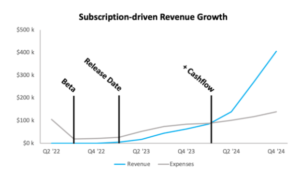
Fig. 1- Revenue growth through quarter 4 of 2024
Interest from State Farm, Geico, and Truckers
During our customer discovery, we had positive talks with truckers on digital forums and various industry experts, including Stan Caldwell (Executive Director at Traffic21 Institute and Mobility21 National University Transportation Center), State Farm Ventures, Pittsburgh meteorologist Brian Hutton Jr., and data scientists from Geico. Stan Caldwell has offered to support Flurry’s MVP testing by working with transportation groups in the Ohio Valley such as PITT OHIO and Pittsburgh Port Authority to get our product into their vehicles. The others expressed interest in our product provided that we complete a minimum viable product and demonstrate its utility.
Obstacles & Challenges
It is important to address questions that any investor would have about our business model. Below are some common questions and how we plan to address them.
Different Vehicle Types: While cars and light trucks must legally have OBD2 ports, heavy trucks have a variety of ports (6-pin, 9-pin, or OBD2), which provides a technical challenge. However, 6/9-pin to OBD2 adapters exist, and we will utilize these for our fleet solutions.
Legal Liability: Another potential challenge is legal liability. A user may claim that our recommendations or maps caused their accident. However, we can avoid these issues by creating terms of service stating that all of our recommendations are suggestions and that the driver must always use their best judgment. Waze has done something similar to mitigate its legal liability. We also acknowledge the data privacy challenges that exist with the company we are proposing. We plan to scramble and de-associate any personal information identifiers (PII). We will also create terms and conditions that outline what data we collect and why, following similar steps as other navigation solutions.
Accurate Mapping: Although we estimate it will take a relatively low amount of vehicles using our solution to reach this level, to ensure that this doesn’t happen, we will target customers that have large fleets of vehicles first rather than individual consumers.
Driver Stigma: Many people don’t want to admit that they need help or are at risk of an accident. We will flip the narrative by encouraging potential customers that our solution is to help them deal with obstacles in a responsible way. We will market the solution in a way that makes drivers think they are a better driver for using the product.
The Three Co-Founders
We are all Swartz Center Innovation Scholars and originally met while working together on Tambo, an entrepreneurship class project that focused on improving the quality of life for truckers, which sparked our interest in the transportation space. Our team follows the tried and tested hacker, hustler, and designer startup structure.
- Our designer is Miguel Brandao, a Mechanical Engineering student. Growing up in Minnesota, Miguel experienced the problem first-hand and ideated Flurry. Miguel has interned with the Minnesota Department of Transportation and conducted civil engineering and human-computer interaction research. He will be a product design engineer this summer at Amazon. His background in engineering has given him experience in modeling mechanical systems, doing dynamic analysis on vehicles, and processing data in MatLab, all skills which make him well suited to develop this technology.
- Our hacker is Steven Wu, a Computer Science and Robotics student. Steven’s rainy, humid hometown of Houston with flood-prone roads taught him the importance of monitoring road conditions while driving, making him passionate about building a solution that makes drivers safer in slick conditions. Steven previously interned at an ag-tech startup, where he built path planners for autonomous tractors and built bomb-detection robots with NASA.
- Our hustler is Jack Winters, a Business Administration student. While calling Austin, Texas home has many benefits, driving in the Texas Hill Country can be treacherous. The region can get torrential rain and a coat of snow in the same week. Also, flyovers are extremely popular in Texas due to their flat geography and freeze quickly, which causes major backups. Jack understands the importance of knowing road surface conditions and wants to mitigate weather-related accidents. Jack co-founded date rape drug detector WingMate in 2017 and worked in high-growth startups before Flurry, such as The Glimpse Group (NYSE: VRAR) which went public in July 2021.